


 Francais
 Deutsch
 Italiano
Refine Your Search
Kiribati Gilbert Islands 1943 stock footage and images
- Showing 409 to 414 of 6726 results more
more Hide
Hide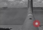
U.S. Air Force runway strips and airfields at islands of Guadalcanal in Solomon Islands, during World War II.
U.S. Air Force runway strips and airfields at islands of Guadalcanal in Solomon Islands, during World War II. A new runway strip at Carney airfield being constructed for U.S. Air Force fighter aircrafts nearby the sea shore of the island. Landing strip between dense forests with coastal trees. equipment and trees cut down for the runway. Another landing strip with few planes parked and houses near side the strip.
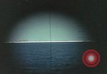
Views through periscope of U.S. submarine off the coast of Midway Island as bombs explode on the island during World War II
As viewed through periscope of submerged American submarine, bombs explode all along the coastline of Midway Island under attack by Japanese bombers (unseen) during World War 2 Battle of Midway. One strike hits oil storage site causing black smoke to rise. Many bombs create high long-lasting clouds of smoke.
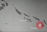
U.S. Army planes attack Japanese locations on the Solomon Islands from Guadalcanal during World War II.
The U.S. Army plans attack at Munda Point on New Georgia group of Islands, Solomon Islands, during World War II. An animated map highlights locations from where the attack is to be launched and Japanese locations to be attacked including Munda, Ballale Island, Vila, Kahili, Buka, and Rabaul. Aerial views of various U.S. air bases in the Solomon Islands. U.S. aircraft in flight. An animation depicts the air cover for U.S. convoy moving between New Georgia and Guadalcanal and the need for fighter patrol. An animated map depicts air attack on Japanese land positions to neutralize air bases and disrupt shipping. The map also depicts direct cooperation of tactical group without ground forces to attack concentrated Japanese troops.
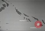
U.S. 13th Air Force plans an attack on Japanese locations on the Solomon Islands during World War II.
U.S. Army Air Forces plans an attack at Munda Point on New Georgia group of Islands, Solomon Islands during World War II. An animated map highlights locations from where the attack is to be launched and the Japanese locations to be attacked including Munda, Ballale Island, Vila, Kahili, Buka and Rabaul. Aerial views of various U.S. air bases on the Solomon Islands. U.S. aircraft in flight. An animation depicts the air cover for U.S. convoy moving between New Georgia and Guadalcanal and the need for fighter patrol. An animated map depicts air attack on Japanese land positions to neutralize air bases and disrupt shipping. The map also depicts direct cooperation of tactical group without ground forces to attack concentrated Japanese troops.
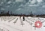
Marines, of 1st Division, fix markers at U.S. Armed Forces Cemetery No. 1, Peleliu Island, Palau Islands in World War II
U.S. Armed Forces Cemetery No. 1, near Orange Beach, Peleliu Island, Palau Islands, in World War 2 . Rows of graves marked by wooden crosses in white beach sand. Two 1st Division Marines secure the crosses. 'Connalay C.H. USA' written on one of the crosses. A Marine kneels by grave with rifle in hand. 'Unidentified' marked on another grave marker.
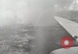
Aerial views of ships at Leyte Gulf, Peleliu Island and airstrip on Biak Island (WW2)
Aerial views of ships at Leyte Gulf, Philippines during World War II. Interiors of C-47 Skytrain shows radio operation, Pilot, Copilot, and Navigator work inside aircraft. Pilot looks through binoculars from the cockpit. Aerial views of Peleliu Island, Palau and airstrip on Biak Island.
CRITICALPAST.COM: About Us | Contact Us | FAQs - How to Order | License Agreement | My Account | My Lightboxes | Shopping Cart | Advanced Search | Featured Collections | Website Terms & Conditions | Privacy Policy ©2026 CriticalPast LLC.
License Agreement |
Terms & Conditions |
Privacy Policy
©2026 CriticalPast LLC.