


 Francais
 Deutsch
 Italiano
Refine Your Search
Melville Rhode Island 1943 stock footage and images
- Showing 601 to 606 of 6722 results more
more Hide
Hide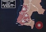
Naval battle, and U.S. 2nd and 4th Marine Divisions advance on enemy positions on Saipan and Tinian in the Mariana Islands.
U.S. forces battle against the Japanese on Saipan, Mariana Islands during World War II. Animated map shows United States forces landing on Saipan. The map displays the position of a Japanese fleet and U.S. Task Force 58. View of Japanese ships being bombed and attacked by aircraft from U.S. Navy 5th fleet ships. A damaged U.S. fighter aircraft lands on an aircraft carrer ship deck at dusk with only its right landing wheel functional. It grinds to a halt without proper landing gear. Dramatic night views of battle as Japanese aircraft attack U.S. Navy warships. Sky filled with barrage of anti aircraft fire. Two Japanese aircraft are hit and are seen in flames as they crash in the sea. U.S. Marine 2nd and 4th division along with U.S. Army 27th Infantry Divisions advance on the island. Marines load and fire guns at the enemy on Saipan island. Firing on Tinian Island also begins. Transports of northern task force arrive for resupply. Animated map shows the territory acquired by U.S. forces.
Views of Midway Island before, during and after the first Japanese bombing attack there in World War II
Japanese bombing attack on Midway Island in World War 2 (Battle of Midway). Opening scene shows map with Midway Island in context .of the Pacific Ocean. A Navy Consolidated PBY Catalina flying boat is seen among clouds. Closeup of the plane from another in formation with it. View of gunner with machine gun in blister of a PBY. Views from the PBY of Midway Island, from above and from low over the water. Two PT boats in the harbor. A PBY seaplane lands and is next seen being towed tail first up an incline, by sailors using lines. A U.S. Marine Corps color guard leads a contingent of Marines marching in formation along a pier, where some submarines are docked. F lock of white sea birds photographed against blue sky and Gooney birds on the white sands of the Island. Marines silhouetted in front of a beautiful sunset. The are relaxing. One plays an accordion. Sentries are alerted by some thunder from clouds in the distance. Next, B-17E bombers are seen near sandbagged positions on the airfield. Air crews gather for briefings. Camera pans over several B-17s being loaded with bombs and refueled. Glimpse of a railroad engineer who served 38 years on the Ironton railroad, standing next to a steam locomotive.( He is ostensibly related to one of the flyers.) Brief views of the flyer’s mother and sister. B-17 taxiing on number 1 and 4 engines (unusual). Several B-17Es taking off. One is Number 41-2524. Others with readable numbers are 41-2611, 41-2632, 41-2648, and 41-2437. Suddenly, several Japanese aircraft are seen in loose trail formation overhead. Marine fires machine gun from a defensive position. Black flak clouds form from exploding U.S. antiaircraft rounds. One Japanese aircraft falls burning toward the sea. Several U.S. Marine Chance-Vought SB2U Vindicator aircraft take off to engage the Japanese bombers. The U.S. aircraft maneuvering overhead. More machine gun fire from defenders on Midway. A bomb explodes close to the camera, sending debris flying. More machine gun fire, and another bomb strikes near the shoreline with a huge explosion. Explosions on other areas of Midway. A hangar burning. Another bomb strike close to the camera. Marines running past burning and destroyed aircraft, and raising the American flag, as fires burned and the bombing continued.
U.S. soldiers unloading equipment from a landing craft and working on a field in the Solomon Islands.
United States troops in the Solomon Islands during World War II. Tactical maneuver of bypassing some Japanese held islands and advancing to more strategic positions is explained. Trucks and jeeps parked on an island. Soldiers aboard vehicles board a landing craft. An officer instructing a group of soldiers. The soldiers aboard the landing craft underway at sea. A barrage balloon in flight overhead. The soldiers look for enemy airplanes. The landing craft underway at sea. The soldiers unloading equipment from the landing craft at an island. Soldiers working with picks and shovels on a field.
American outpost built at the Enewetak Atoll in Marshall Islands for atomic testing.
Covers events relating to the Operation Greenhouse atomic tests. Shows U.S. troops and men at an American outpost at Enewetak Atoll (sometimes spelled Eniwetok or Eniewetok) in Marshall Islands. A water pumping station on the island. Boats and small planes provide transport facility on the island. The test island serve as a learning ground to U.S. Army, Navy and Air Force. Tanks fitted with measuring instruments are stationed near the Zero Tower to measure the radioactivity ,heat and pressure generated at the time of blast. Reinforced concrete buildings are build to withstand the atomic blast. Test objects like an airplane wing and fuselage section are positioned to study the effect of blast on them. U.S. parachute troopers stand beside a transport plane. Commander and his crew at the Joint Task Headquarters in Perry Islands,USA, make final decisions before the atomic test on Enewetak. Unmanned B-17s and fighter jets take off at night to collect valuable information during the blast. View of the atomic bomb explosion and its effect on the buildings at the test island.
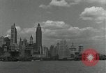
New York Harbor, Liberty Island, and views of Manhattan Island, New York City in the United States
View of New York City skyline in the United States. Statue of Liberty situated on Liberty Island. Cruise ships, ferry boats and sail boats are seen moving near the statue and near lower Manhattan. Some of the scenes appear to be dawn or dusk with the city skyline more dark.
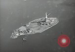
A New York City Police airplane in flight over Liberty Island. New York Harbor, Manhattan Island, as seen from another aircraft
Aerial view of the Statue of Liberty on Liberty Island in Upper New York Bay. Aerial view of ships in New York Harbor. An airplane in flight. Airplane is flying over the New York Bay and the skyscrapers and tall buildings of the Manhattan skyline. Aerial view of New York harbor. 'Police' can be seen written on the aircraft.
CRITICALPAST.COM: About Us | Contact Us | FAQs - How to Order | License Agreement | My Account | My Lightboxes | Shopping Cart | Advanced Search | Featured Collections | Website Terms & Conditions | Privacy Policy ©2026 CriticalPast LLC.
License Agreement |
Terms & Conditions |
Privacy Policy
©2026 CriticalPast LLC.