


 Francais
 Deutsch
 Italiano
Refine Your Search
Walcheren Island Netherlands 1944 stock footage and images
- Showing 31 to 36 of 9701 results more
more Hide
Hide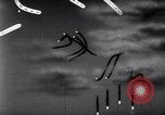
Battle between Allied and Japanese naval-air forces during the Battle off Samar near the island of Leyte in the Philippines.
Shows the Battle off Samar which was the central action of the Battle of Leyte Gulf. It took place in the Philippine Sea off Samar Island near the island of Leyte in the Philippines on 25 October 1944. Animated map shows battle between Allied naval-air forces and Japanese naval-air forces. Japanese kamikaze suicidal dive bomber strike on Allied fleet and inflict heavy damage to a few Allied ships. (World War II period).

Battle off Samar near the island of Leyte in the Philippines, during World War 2.
Shows the Battle off Samar which was the central action of the Battle of Leyte Gulf. It took place in the Philippine Sea off Samar Island near the island of Leyte in the Philippines on October 25th 1944. U.S. air forces launch a counterattack on the enemy's ground forces. Animated map shows heavy battle between Allied naval-air forces and Japanese naval-air forces. Allied AA guns fire at Japanese kamikaze suicide dive bombers. One of the dive bombers strikes USS St Lo (CVE-63). View of U.S. Navy aircraft on carrier deck in flames. Narrator indicates the St. Lo was sunk. Views from some miles away of smoke pouring from U.S. aircraft carrier. The results of the battle shows heavy damage inflicted to the Allied naval fleet.

Allied troops capture the island of Hollandia, Indonesia under the leadership of General MacArthur during World War II.
Allied troops invade Hollandia, Indonesia during World War II. United States ships underway in the Pacific Ocean on April 22, 1944 to attack Japanese positions in Hollandia. The ships underway as United States Army General Douglas MacArthur looks at the convoy from United States cruiser USS Nashville (CL-43). Radars on alert in case of enemy attack. A United States destroyer transfers mail aboard the USS Nashville. Troops being briefed aboard a ship. Naval guns fire at the coast during night and flaks burst. American carrier planes bombard Japanese position on the island. Allied ships underway as planes fly overhead. Troops in landing crafts as they head for the beach. Allied troops disembark from the crafts and advance inland. Trucks, tanks and troops unload from landing crafts. Allied soldiers walk through mud as they advance. General MacArthur gets off Nashville and inspect an airfield under construction on the island.
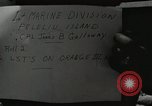
U.S. Navy and Marine Corps combat operations at Peleliu Island, Palau, during World War II.
U.S.LST-129 and the second USS Seaward (LST-278) next to each other, in rough surf at rock strewn Orange Beach III, Peleliu, in the Palau Island group, during World War 2. These two LSTs collided and suffered damage on October 2, 1944. View of airfield with U.S. F4U Corsair aircraft parked. An F4U landing on the runway. Another aircraft takes off. Construction equipment and tents seen on airfield. A PBY Catalina aircraft takes off. Change of sequence shows battlefield with bare trees. F4U aircraft flying low and slow, with landing gear extended, drop bombs, raising heavy smoke clouds, at Japanese positions just beyond a nearby ridge.

Chart illustrating progress of U.S. campaign against Peleliu, Palau Islands, during World War II.
View of situation map showing various actions by U.S. forces during the battle for Peleliu Island, Palau, from September 15th to October 15th, 1944. Key events are marked on the map in terms of D+days. View of tents on ground.
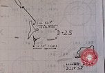
Situation map showing key events and dates during battle of Peleliu, Palau Islands, during World War II.
Map showing progress of battle for Peleliu, Palau Islands, during World War 2. D+25 and D+24. (commencing with start of campaign on September 15th, 1944) are shown on map.
CRITICALPAST.COM: About Us | Contact Us | FAQs - How to Order | License Agreement | My Account | My Lightboxes | Shopping Cart | Advanced Search | Featured Collections | Website Terms & Conditions | Privacy Policy ©2026 CriticalPast LLC.
License Agreement |
Terms & Conditions |
Privacy Policy
©2026 CriticalPast LLC.