


 Francais
 Deutsch
 Italiano
Refine Your Search
Melville Rhode Island 1943 stock footage and images
- Showing 397 to 402 of 6722 results more
more Hide
Hide
U.S. aircraft take off and U.S. Army officers in the Aleutian Islands, Alaska.
The Aleutian Islands Campaign of World War II. A map shows the Aleutian Islands situated in the North Pacific Ocean forming the southern boundary of the Bering Sea. Volcanoes in the Aleutian Islands. The rocky coast of the island. A man stands on an ice covered ship. A boat carries some people. An aircraft lands on sea. A ship in the rough seas. In 1942: Animated map depicts Japanese invasion of Midway Island and Dutch Harbor and U.S. response to the attack. U.S. Army Air Force PBY Catalina flying boat aircraft takes off. U.S. Army officers who participated in the Battle of Dutch Harbor include Lieutenants Charles H. Briggs, Jack Todd, Jep C, Jonson, James E. Breeding, Virgil Alleman and Jack S. Marks. Active volcanoes in the background. Army camps in the Aleutian Islands.
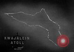
Code names of islands and operations of United States forces on Kwajalein Atoll in the Marshall Islands during World War II.
A training film on operations of United States forces on Kwajalein Atoll in the Marshall Islands during World War II. Animated map locates Kwajalein Atoll. Islands, atolls and operations are given code names. The code name for Kwajalein Atoll is Carillon atoll. The operation's name is Flintlock Operation. The Arnold pass and the Cohen Island. The code names are given alphabetically and begin with Abraham and end with Jasper. The areas of Roi Island and Namur Island are called Burlesque and Camouflage respectively. The 4th Marine Division is active in the northern area and is called Task Force 53. The southern attack force is the 7th Division and is called Task Force 52. Burlesque and the Camouflage islands are located. The two islands are connected with a concrete causeway. Average annual rainfall in the area is about 80 inches. Average annual temperature is about 81 degrees Fahrenheit. Out of the 25 navigable passes into the lagoon, only 6 are considered good. These are Jacob Pass, Ivan Pass, Bennett Pass, Chester Pass, Conrad Pass and Elton Pass. Flow of wind and current in the area is shown.
U.S. troops make amphibious assault on Makin Island, Gilbert Islands in the Pacific during World War II
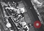
U.S. Army troops from elements of the 27th Infantry Division, clamber down a rope net over the side of the Attack Cargo Ship, USS Alcyone (AKA-7) and board her landing craft for an amphibious assault on Makin Island, during World War 2 in the Pacific. Views of Higgins Boats (landing craft) underway, some from the USS Leonard Wood (APA-12). Explosions on the shore from Naval bombardment. View from inside a packed landing craft approaching the shore. Gunfire from U.S. Naval warships offshore. Various views of the landing craft underway. An aircraft flying close over the water in the background. A wounded person being hoisted aboard one of the transport ships. Heavy black smoke rising from Naval gunfire striking the shore. A line of landing craft. View from front of a landing craft about to hit the beach. U.S. troops wading ashore.
U.S. convoy of freighters, aircraft carriers, and LSTs, reaching Saipan Island, Mariana Islands in World War II
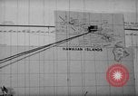
The Pacific Campaign on the Island of Saipan, Mariana Islands during World War 2. Map titled 'Mariana Islands' showing the location of U.S. carrier convoy. Map showing the location of LSTs (Landing Ship, Tank). Map with heading '804th Aviation Engineers in Saipan'. Map and sea route marked from Hawaii past Johnson Island showing location of transport convoy, June 17, 1944. Convoy at sea showing men aboard the ships looking down at the water. Convoy showing the various types of vessels in the convoy, mostly freighters. Continuation of maps with sea markings of the route of the convoy showing the location of Kwajalein Islands and location of Eniwetok. Carriers underway showing planes aboard the carriers. Personnel on look out, aircraft spotters and others. Huge geyser of water erupting near a freighter. Convoy off the coast of Saipan showing a huge geyser of water going up. LSTs and freighters at anchor off the coast of Saipan. Personnel aboard LST as they move in towards the shore. Gun flashes can be seen ashore. Unloading operation showing the LST pulling into shore, the door falls down into the water and a half track pulls out and moves into the shore loaded with men and equipment. Trucks, jeeps and all types of equipment moving across the water in toward shore. Men walking ashore.
Animation locates areas of Burlesque and Camouflage Islands under northern attack forces in Kwajalein Atoll, Marshall Islands.
A training film on operations of U.S. forces on Kwajalein Atoll in the Marshall Islands during World War II. A map locates places which are under northern attack forces. Burlesque Island is located. Camouflage Island. Areas captured on the islands. A large concentration of Japanese buildings on Camouflage Island. Radio and radar stations are installed by the Japanese in these areas.
U.S. troops occupy Albert and Abraham Islands on Kwajalein Atoll in the Marshall Islands.
A training film on operations of U.S. forces on Kwajalein Atoll in the Marshall Islands during World War II. Aircraft in flight overhead. The aircraft drop bombs over target areas. Smoke rises from bombardment. Animated map locates Burlesque, Camouflage and Allen Islands. Landing teams come ashore. Trees on the shore. Men fire rifles at the shore. They fire machine guns and artillery. Rubbled houses and buildings. Animation shows the capture of Albert Island. Smoke rises from the island. The occupation of Abraham and Albert Islands.
CRITICALPAST.COM: About Us | Contact Us | FAQs - How to Order | License Agreement | My Account | My Lightboxes | Shopping Cart | Advanced Search | Featured Collections | Website Terms & Conditions | Privacy Policy ©2026 CriticalPast LLC.
License Agreement |
Terms & Conditions |
Privacy Policy
©2026 CriticalPast LLC.